

Cachestatistik anzeigen
Bosleerpad - OB1448
The Bosleertrail Bocholt-Lozen (towards Kaulille). Belgium “Kempen
Besitzer:
TVTULPENLAND
 Bitte logge dich ein, um die Koordinaten zu sehen.
 3x gefunden
  0x nicht gefunden
  1 Bemerkungen
  2 Beobachter
  Bewertet als: n/a


 Cacheattribute


 Beschreibung
open from sunrise to sunset. From April 1 to August 1 open from 7:00 to 21:00
"The Bosleertrail Bocholt-Lozen (towards Kaulille). Belgium “Kempen”
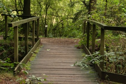
The Lozer Bosleertrail, in fact the “Lozerheide” (heather of Lozen), is a beautiful protected piece of nature conservation, close to lock 17 in Bocholt-Lozen (towards Kaulille).
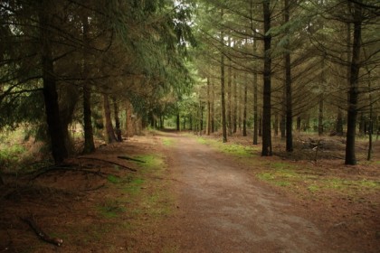
Recommendable to nature lovers and walkers.
The tracks are even quite accessible with strollers, especially if it hasn't been raining for a while.
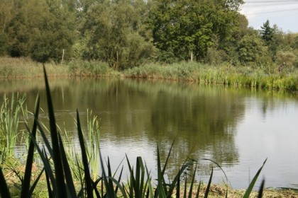
Relax and enjoy the Lozerheide (or Bosleertrail). You can do a nice walk around the pond in the beautiful environment. And even enjoy a picknick at the little house (as long as you don't leave any trash of course).
The house is not accessible, but you can easily walk around it. You get there by just following the tracks from the start.
To all geocachers (opencaching) with a GPS: follow the cache route by following the instructions below
You can park your car at the coordinates on top of this page.
Walking and biking is allowed here. Look at the signs where exactly biking is allowed. Only walk on pathways and tracks that are marked, unless the conservator allows you.
Loose dogs are NOT allowed (you risk a high fine)
Be always aware of ticks. Make sure your skin is well covered, and check yourself on ticks afterwards and remove them.
The area contains many deciduous trees, pines, ponds, ditches, and swamps and lots of other plants and many birds. A must for any nature lover.
The walk starts at the parking.
Waypoint 01
N51° 12.490 E005° 32.12
You find two white signs with a prohibitation on top of each other
How many vehicles are on the top sign?
A=1
A=2
A=3
Waypoint 02
N51° 12.671 E005° 32.397
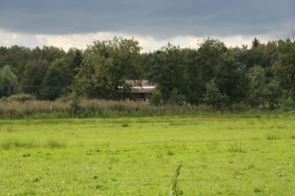
This is a lone little house, meant for the conservators and workers in this area.
At the right of the house is an information panel. Which of the birdfamilies has a belgium name?
B=Jay (Vlaamse gaai)=6
B=Cormorant (aalscholver)=7
B=Hawk (havik)=8
waypoint 03
N51° 12.876 E005° 32.711
Find the tree. How many colors are painted on it by the conservator?
C=1 color =1
C=2 colors=2
C=3 colors=3
waypoint 04
N51° 12.697 E005° 32.866
Here you find a tall tree stump with information panels. How many stars do you count on the top round sign?
D=2
D=3
D=4
Waypoint 05
N51° 12.548 E005° 33.342
What color has the top of the pole next to the track?
E=Blue=1
E=Red=2
E=Green=3
Waypoint 06
N51° 12.804 E005° 32.964
Not really a question at this point. Take a picture of what you find here and upload it with your log, please.
Waypoint 07
N51° 12.418 E005° 32.567
What digit do you find at this pole?
F=1
F=2
F=3
Find the cache after solving this calculation:
N51° 12.A(C+4)(D+5) E005° 32.BEF
I hope you enjoyed your walk.
Golden-Dragon wishes you a nice walk, and if you find the cache, write your name in the logbook. Don't hesitate to leave some coins, trackables etc. And most important: tell how you liked the walk in your log and at the forum.
This cache is presented to you by Golden-Dragon ( Weert Nederland) Nederlands Kempenstreek.
"The Bosleertrail Bocholt-Lozen (towards Kaulille). Belgium “Kempen”
The Lozer Bosleertrail, in fact the “Lozerheide” (heather of Lozen), is a beautiful protected piece of nature conservation, close to lock 17 in Bocholt-Lozen (towards Kaulille).
Recommendable to nature lovers and walkers.
The tracks are even quite accessible with strollers, especially if it hasn't been raining for a while.
Relax and enjoy the Lozerheide (or Bosleertrail). You can do a nice walk around the pond in the beautiful environment. And even enjoy a picknick at the little house (as long as you don't leave any trash of course).
The house is not accessible, but you can easily walk around it. You get there by just following the tracks from the start.
To all geocachers (opencaching) with a GPS: follow the cache route by following the instructions below
You can park your car at the coordinates on top of this page.
Walking and biking is allowed here. Look at the signs where exactly biking is allowed. Only walk on pathways and tracks that are marked, unless the conservator allows you.
Loose dogs are NOT allowed (you risk a high fine)
Be always aware of ticks. Make sure your skin is well covered, and check yourself on ticks afterwards and remove them.
The area contains many deciduous trees, pines, ponds, ditches, and swamps and lots of other plants and many birds. A must for any nature lover.
The walk starts at the parking.
Waypoint 01
N51° 12.490 E005° 32.12
You find two white signs with a prohibitation on top of each other
How many vehicles are on the top sign?
A=1
A=2
A=3
Waypoint 02
N51° 12.671 E005° 32.397
This is a lone little house, meant for the conservators and workers in this area.
At the right of the house is an information panel. Which of the birdfamilies has a belgium name?
B=Jay (Vlaamse gaai)=6
B=Cormorant (aalscholver)=7
B=Hawk (havik)=8
waypoint 03
N51° 12.876 E005° 32.711
Find the tree. How many colors are painted on it by the conservator?
C=1 color =1
C=2 colors=2
C=3 colors=3
waypoint 04
N51° 12.697 E005° 32.866
Here you find a tall tree stump with information panels. How many stars do you count on the top round sign?
D=2
D=3
D=4
Waypoint 05
N51° 12.548 E005° 33.342
What color has the top of the pole next to the track?
E=Blue=1
E=Red=2
E=Green=3
Waypoint 06
N51° 12.804 E005° 32.964
Not really a question at this point. Take a picture of what you find here and upload it with your log, please.
Waypoint 07
N51° 12.418 E005° 32.567
What digit do you find at this pole?
F=1
F=2
F=3
Find the cache after solving this calculation:
N51° 12.A(C+4)(D+5) E005° 32.BEF
I hope you enjoyed your walk.
Golden-Dragon wishes you a nice walk, and if you find the cache, write your name in the logbook. Don't hesitate to leave some coins, trackables etc. And most important: tell how you liked the walk in your log and at the forum.
This cache is presented to you by Golden-Dragon ( Weert Nederland) Nederlands Kempenstreek.
 Zusätzliche Wegpunkte
| Station | Symbol | Typ | Koordinaten | Beschreibung |
|---|---|---|---|---|
| 1 |

|
Physische Station | --- | Hier zie je 2 witte (verbods)borden boven elkaar.Hoeveel voertuigen zie je op het bovenste bord? |
| 2 |
|
Physische Station | --- | Hier ziet u een eenzaam huisje, Voor de beheerders en werkers in dit gebeid. U ziet rechts van de huisje een Informatie bord. Welke vogelsoort heeft een Belgische naam |
| 3 |
|
Physische Station | --- | Zoek hier de boom hoeveel kleuren telt u hier (Dus de verf kleur die er op geschilderd is door de beheerder) |
| 4 |
|
Physische Station | --- | Hier ziet u een hoge boomstronk met informatieborden hoeveel sterren ziet u op het bovenste ronde bordje? |
| 5 |
|
Physische Station | --- | Hier vind u een paaltje naast het pad. Welke kleur ziet u op de kop van dit paaltje? |
| 6 |

|
Virtuelle Station | --- | Hier niet echt een vraag. Maar maak hier een leuke foto van wat u zo al ziet, Laad deze op bij uw log. |
| 7 |
|
Physische Station | --- | Welk cijfer ziet u op dit paaltje? |
 Verschlüsselte Hinweise
Du musst eingeloggt sein, um die zusätzlichen Hinweise zu sehen.
 Naturschutzgebiete
|
Der Cache ist wahrscheinlich in einem Naturschutzgebiet versteckt. NATURA 2000
:
Hamonterheide, Hageven, Buitenheide, Stamprooierbroek en Mariahof - BE2221314 |

|
 Bilder

 Logeinträge:
3x
0x
1x
Logeinträge:
3x
0x
1x


